Thursday, June 7, 2018


Shifting shorelines: a process-based approach
to sea level rise resilience in Grays Harbor estuary
(2017 Master of Landscape Architecture thesis) 

Structures and partnerships 

for sustainable fisheries 
in El Salvador's Bahía Jiquilisco

Harvest Park


Jumping Watersheds,

From Wetland to War Machine
tracing historic shorelines of
the Duwamish River watershed
and Lake Washington

Launch Day 2200

a regenerative settlement on Mars
to improve life on Earth

Saturday, April 7, 2018

It all starts with a question: Global tidal energy harvest?

Future tidal energy production hotspots, based on the energy dissapated as water collides into continental shelves.

Tidal energy - and how to harvest it - came up twice in the past week.  Once via an engineer's presentation to the Washington Coast Marine Advisory Council, and later in conversation with a rural coastal community leader.  The former was interested in generalized sustainable energy production for the region, while the latter was in regard to addressing energy needs for desalinizing water for local use.

Today's energy infrastructure has a definitive footprint on the economies and environment of today's energy-producing regions.  Oil refineries, windmills, and mines create familiar yet profound landscapes.   Tidal energy has yet to take hold, but has massive potential: potential for human development demands to further alter our oceans, and potential for the cosmotic planet-moon-gravity-water* relationship to feed these demands in perpetuity**.

How would new mega-infrastructure for tidal energy capture play out locally? How would it impact global systems?  The map above points out tidal energy hotspots around the globe, where a new industry could take root.  Below is a map of current oil and shale hotspots. 

For comparison: oil and shale gas basins, drivers of today's world.  Map via US Energy Information Administration.
*Earth's gravity holds the water to the planet, while our moon's gravity pulls it away.  As the two rotate and revolve, we get tides.  

**though the slowing of Earth's rotation could alter these dynamics... or cause an increase in earthquakes, and resulting events such as tsunamis. Though this all may likely occur on a timescale greater than we can usually act on, many coastal communities have already experienced, rebuilt from, planned for tsunamis.  Much of this planning is happening today, so perhaps this line of thought could factor in to risk assessment, project design, and prioritization: 
the creeping speed of Earth's deceleration, 
connected to potential increased likelihood of earthquakes in certain locations, 
connected to the likelihood of ensuing tsunamis impacting these locations... 
Risk = impact x probability

Egbert, G.D.; Ray, R. (2001). "Estimates of M2 tidal dissipation from TOPEX/Poseidon altimeter data". Journal of Geophysical Research. 106 (C10): 22475–22502., via Wikipedia "Tidal Resonance" page

Monday, February 1, 2016

FTB40 - "Antarctic Icebergs as a Global Fresh Water Source," 1973

"This report is intended to provide background knowledge for potential users and suppliers of Antarctic icebergs"


p 17: "Two Routes from Antarctica to Southern California"

The Colorado River pulse flow momentarily opened the Morelos Dam and sent water across the Mexico-US border, down the parched riverbed to the Sea of Cortez.  The only other consistent terrestrial input of water to the basin for years prior came from a desalting facility in Arizona, which sent spoil water through pipes to the Colorado River's estuary.  Heavy water users such as Cali's Imperial Irrigation District are in search of ways to augment the Colorado's existing high-demand flow.   

"Transit time, long route"

Friday, August 28, 2015

FTB 39 - Lower Mid-City, New Orleans


In the move to Seattle, I uncovered some unfinished business, circa 2009


In the process, Grand Palace Hotel implosion became city-wide block party.   Then everyone got dusted out.  This is not my video.  I was on top of a CBD parking garage. There was much concern that the dust would harm elderly residents at the Iberville Projects but wind conditions worked out, it seems.

Tuesday, May 5, 2015

FTB38 - new sound sketchbook

Guitar, drums, clangy pitched thangs.  Check out the first 5 from the 4 track:


Wednesday, April 22, 2015

FTB 37 - Ras Al Khor, Dubai


Ras Al Khor ("Head of Creek") is a Ramsar Wetland of International Importance, located smack in the middle of one of the fastest-growing cities.  In the center, a grey heron and flamingo catch shade and look for food.  Background - Burj Khalifa, Earth's tallest building.

Ras Al Khor Wildlife Sanctuary lies at the head of Dubai Creek, along the Central Asia-Africa flyway.  These tidal mudflats, mangrove swamps, and desert wetlands provide migrating birds a rest stop at the edge of endless dunes that make up the Arabian Peninsula's Empty Quarter to the southwest.  Birds use Southeast Louisiana's barrier islands in a similar way before crossing the Gulf of Mexico.  I visited Ras Al Khor in early April while staying in Sharjah.

Waterway edges have been drastically altered by humans and surrounded by buildings.


Water taxis carry folks between sides of Bur Dubai (Old Dubai) upcreek from Ras Al Khoor.  Edges of the creek are lined by wharfs, restaurants, malls, hotels, and other built interventions.


Restoration of Ras Al Khor began in 1985.  Camel had previously grazed the area barren.  Hydrologic disconnection from tidal energies comes from upstream dredging, built developments, and pollution barriers.  Tidal shifts are artificially created by a pump station at the head of the creek.  


Access to Ras Al Khor is barred except for select spots.  Here is public birdwatching blind, constructed with traditional date palm fronds woven together. Last year 15,000 people visited the location.  Bayou Sauvage in New Orleans (a city with 25% Dubai's population) hosts 50,000 people annually.
Ras Al Khor Wildlife Sanctuary provides binoculars, tripod telescope, and identification books for guests.  Nice touch.  Here is another grey heron.

For more on the Ras Al Khor wetland and its story, take a look at “Ras Al Khor – Eco-tourism in constructed wetlands: post modernity in the modernity of the Dubai Landscape”.  Chris Ryan, Heba Aziz, and Ivan Ninov have written a a readable, short academic paper on Ras Al Khor and the development around it.  It also contains more info on "The Lagoons", a huge residential development currently under construction next door, marketing luxury life and boating in the wetlands.  

Monday, March 23, 2015

FTB36 - Barrier Island Shifts, Documented

Between 1984 and 2007, Karen Westphal* used time-lapse aerial photography to document shifting barrier islands along the Louisiana Coast while longshore transport, breaking waves, built structures, and other factors impact the movement of sand and sediment. Check out the links:

I find the following images to be very helpful in understanding the processes that Karen has documented.

Barrier island accretion through drumstick model.  The opposite can also happen, as an island is split by wave washover.
Grand Isle, Lousiana.  Photo taken from edge of beach.  Note how currents have dropped sand loads between beach and rock wall.  Birds often hunt here.

From Andrew Barron of Barataria Terrebonne National Estuary Program (BTNEP)

relatively new delta lobes of the Mississippi River, now constrained to the Balize delta course

older geologic features, well below the surface
Southeastern Louisiana is disappearing.  It's well-known, and it's a complicated equation.  Levees and human-made hydrologic barriers prevent Mississippi River sediment from building land atop fault lines while industry drains subterranean oil reserves and salt domes.  Trade channels have altered salinity throughout the Pontchartrain Basin while Gulf wetlands are devastated by salinity intrusion through exploratory oil canals.  The region's urban areas are subsiding after pumping all water away from development, drying out soils that rely upon water for structural stability, and replacing swampland with impervious surfaces.  That's not all, but it's a start.  Long story short: in the history of development along the lower Mississippi, natural systems have not been given due attention.  Engineering did not beat out nature, and we are now short of breath (and money) trying to catch up.  Natural systems shift and adapt, often more slowly and powerfully than human-built systems.  The barrier islands of Louisiana are a great example of this.

*Karen is a scientist working for National Audubon Society's Louisiana Coastal Initiative and is involved coordinating the Louisiana Master Naturalist Program.  I'm stoked that she shared this with me, I hope you enjoy it.

Monday, January 26, 2015

FTB35 - archaeological artifacts (updated 3-16-15)

from Wealth and Physical Stamina:

SUNDAY, JANUARY 25, 2015


PAST TENSE PRESENT TENSE

Between 2008-2013 WNPS documented short-lived bands worthy of replay.  Many of these tapes were never released to the public as members went on to other projects.  As these 4-track master tapes resurface, we will digitize + compile them here with downloadable links.  You can also listen via Youtube, with tracks listed.  

family treasure trove:
Sparrowhawk
Nervous Juvenile
Firebrand (download here, see below for stream
Heat Rash (download here, see below for stream)
Brothers (download here, see below for stream)
Relax Band

Here are some old WNPS cassette releases to listen to:
WNPS01: Skin Shit - Prom Teeth
WNPS02: Gas Explode - Shrivel, Squirt, Implode
WNPS05: Necro Hippies - Sore Throat
WNPS06: Fisher Cat - Apocalypse
WNPS07: Fisher Cat


Thursday, January 22, 2015

FTB34 - Paths to Land

The old dusty "Freedom to Build" thought that the processes for legally accessing vacant property around town were quite hard to interpret.  This veil has contributed to a skewed sense of who can access vacant property to enliven neighborhoods, and should be lifted!   We pored over documents, visited sites, and interviewed folks until all of our brains' water evaporated.  The outcome was the tri-fold "Paths to Land Use" pamphlet. 

Download it here.  It's a tri-fold, so it looks wacky until it's folded.  


Labyrinthine processes created + intertwined consciously, worded in a foreign tongue... "Post-Kelo Era"?

Sunday, January 4, 2015

FTB33 - "Water on Display" from 1968


explanation of environmental processes with mid-1900's graphic design


In 1968 the United States was waking up to industrialized population growth's adverse effects on natural systems that we rely upon, and the US Geological Survey compiled 100+ graphics from public presentations explaining complicated hydrologic + geologic processes.  "Water on Display" documents posters by USGS's Water Resources, Conservation, Computer, Geologic, Topographic, Marine Research, and Recruiting Divisions.  

Take a look! You can download it HERE (28MB medium resolution) and HERE (9MB low res).  I've reduced the resolution to create a manageable filesize. Hopefully this hard-to-find document can be of interest to others working with public environmental education and have renewed relevance as water management issues continue to shape the future of our existence.  See the Data Center (formerly Greater New Orleans Community Data Center) report: The Water Workers: Workforce Opportunities in Water Management in Southeast Louisiana

The USGS still has reports available on all sorts of detailed topics via their maps + publications, lending programs with their library, and localized project sites such as Water Resources of Louisiana.  This is from San Diego's brand-new 9-story Central Library, which houses a high school, art gallery, event space, and more.  

Tuesday, December 23, 2014

connection


Golden Orb Weaver (Nephila clavipes) web successfully cornered this wasp nest at an abandoned camp east of Bayou Boeuf's mouth along Lac Des Allemands.  Wasps not using nest anymore.  "Check mate."  Perhaps some wasps survived.  The Orb Weaver's web spread across a wide opening adjacent to this corner.  The spider was dead and dried on the web, testifying to their silk's strength.  Curious of the timeline of these events.


Landscape Ecologist Richard Forman talks about a web of urban growth patterns, culture, natural systems, and our world's future through a bioregional perspective on human development.    See Max Cafard

Friday, October 31, 2014

New Orleans' Adventure Playground


 Black Cat Moving supports Parisite Skatepark.  "Affordable, experienced, and reliable. (504) 302 8598."

Parisite Skatepark has grown from a DIY Bring-Your-Own-Ramp park to an official New Orleans Recreation Development Commission recreation space. Interspersed throughout the permanent concrete ramps, Parisite sretains elements of an adventure playground, with loose parts all around - movable and available for interpretative use by park participants. 

loose parts at Parisite, large and small.

By Lady Allen of Hurtwood's standards*, there are two official "adventure playgrounds" that I know of in the US -- many more if you count informal spaces.  This lack of much-needed exploratory learning environments for youth  is connected to the liability insurance required for public play spaces: widely-recognized codes and standards (ASTM International) guarantee safety and longevity of play structures by describing approved construction materials, designs, and methods.  What are acceptable safe "best practices" for playground elements that are impermanent and open to interpretation, with risk as an essential park of play? 

Charlie Thomas in New Orleans, from the first Preservation Skateboards ad.  When static forms are a part of a playground, the flexibility of how we interface with these forms determines the possiblities for play.  Variation in form + imagination + flexible tools = infinite possibilities of interaction.

Enter skateboarding: a relatively brand-new form of recreation, it is the 3rd most popular teenage sport in the United States and sorely underrepresented in most parks systems.  Based in free-form creativity and exploration of our environment, some cities have even developed skatepark master plans (Seattle Citywide Skatepark Plan is a great example of this).  ASTM F2334-09 - "Standard Guide for Above-Ground Public Use Skatepark Facilities" specifies methods for safe skateable space, which can be moveable and open to interpretation.  By creating specifications for accepted replicability, these ASTM standards allow for municipalities to accept + insure skateparks instead of pulling out bulldozers in fear of someone hurting themselves.  By paying attention to ASTM Standards, Parisite Skatepark's DIY features were not demolished by the forces that be, and instead have been accepted by a recreation department looking for relevant ways to provide for local youth. 

Is it best to take something as organic, spontaneous, and alive as adventure play and codify it for acceptance?  How far can a "best practice" be stretched to balance invigorating, innovative, efficient usage of our world with safety?  I can't answer that. But if it is a means towards folks of all ages accessing otherwise-nonexistant physical, unprescribed, and interactive environments, I'm for it. 

Will free play keep humans from becoming cyborgs?  Not by itself, but it's a start!


*"There was a wealth of waste material on it and no man-made fixtures. The children could dig, build houses, experiment with sand, water or fire and play games of adventure and make believe." via Play and Playground Encyclopedia

Sunday, September 7, 2014

moving water elsewhere.

best buds in the rain.

canal waters froze time. 

Thursday, September 4, 2014

wetland flux


On a recent job we replicated flotants in open cisterns used to manage stormwater, primarily using driftwood to create a substrate for soil + plants to hold onto.  Dr. Thomas' mention of the change from floating marsh to swamp forest as woody plants root and take over reminds me of a recent trip to Pinckney Island National Wildlife Refuge, in South Carolina just above Savannah, GA.  Shown in the photo below, cattails are involved in transforming this freshwater pond into a maritime forest -- as cattails fall, they fill in the swamp's depression and build soil as they break down. 

White Ibis rookery.  Scarlet Ibis are in the area as well but are more easily found around the Savannah Wildlife Refuge to the southwest.

mama gator, about 11' long.  We counted 12 young gators in the area, each about 30" long - swimming, basking, and resting in the shade. Note Typha (cattail) colonizing exposed mud.


About 2/3 of the Pinckney refuge is comprised of salt marsh and tidal creeks, where Ibis can be found eating.

Sunday, August 24, 2014

Union, SC, Hwy 215

Friday, March 21, 2014

"Dinosaur Apocalypse, erase the human parisite"

So a few coyotes are all up in City Park, and have killed some peoples' pets, and its up on the news etc. Growing up, undomesticated animals regularly lead to injuries/deaths of my own + friends' pets. In many areas it is common knowledge that animals attack other animals.  I remember when an alligator ate  a friend's date's dog, while on a walk in City Park years ago.  In San Diego, lost cats are assumed to be coyote snacks, no big deal. [RIP Spot, gotta watch out for them possums]

I hope they don't attack a kid (which hasn't happened, but people are scared of it), in the same way that I hope a car doesn't run over a kid (which happens regularly, but driving is so convenient), or that someone isn't booted from their house in favor of a more financially stable resident (which I'm sure can be connected to all of this but its too early in the morning and you don't wanna read me rant).

Coyotes are invasive, and so is the human. Coyotes have a mechanism for handling excessive population density: fighting intruder coyotes, potentially to the death. Rumor has it that many coyotes were actually unsuccessfully brought to NO, to solve the invasive nutria problem, who were introduced in 1930's from S America for fur farming industry. But thats another story. At what point do we concede that people have changed the environment so much that many "invasive" species are actually "mismanaged" due to our own invasiveness, overdevelopment, and general messing with everything for our own benefit without expectation of repurcussions?? Our population is tipping the environmental seesaw down into the mud til it aint a fun game anymore and on the other end we are rocketing any non-human entities into space because its OUR game and THEY don't get to help choose the rules.

Thinking of situations in which animal (or plant, etc) populations have been accounted for as human populations expand. Like, wildlife crossing bridges, or even less after-the-fact*. What examples do you have, where human infrastructure and development has made ways for coexistence with the untamed world?

wildlife crossing at Banff Nat'l Park, Alberta, Canada (via Twisted Sifter link below)

 Amazing Animal Bridges Around the World, via Twisted Sifter
A History of Urban Coyote Problems, by Robert M Timm + Rex O Baker

*due to nature's resilience, achieved over millions of years, the repercussions of human actions often go without visibility for a long time (as viewed by such short-lived creatures as humans).  This means that the initial (often forseeable yet ignored) harm on the environment is sometimes passed on to unsuspecting populations in the future, or simply acknowledged in some way later on (such as creating landbridges over existing highways).  Any stats on how often wildlife bridges are constructed at the same time as the highways they try to mitigate?

Tuesday, December 17, 2013

Dizzy Machinery

While nerding out on metal fabrication*, it struck me that if Richard Serra's awesome, sobering metal sculptures were twisted just a bit, they would become inclined planes that one could walk on, like this great playground by Mitsuru Senda:


Saturday, June 15, 2013

Stallings Gentilly Park + Pool... Istanbul's Gezi Park.

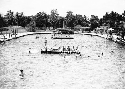
As the New Orleans heat index reaches 110 degrees, it seemed wise to pick back up the old summer tradition of swimming at the Stallings Gentilly Pool , a few blocks away from the posi-vibes breakfasts at Espe's Kitchen at Broad and Aubry.  The park is named after Olive Stallings, "mother of playgrounds in New Orleans."

bleached out at City Park
 
There used to be a pool at City Park as well, but it was closed under segregationist mayor Victor H Schiro in the 1960's to avoid integration (along with public pools at Audubon Park and Ponchartrain Beach).  This caused several generations of New Orleanians to not know how to swim - compounded by pollution in Lake Ponchartrain, which was not considered passable for swimming until 2006.

Friday, June 14, 2013

transport to the next dimension

Project for Public Spaces sees that primary transportation in this country is with individual automobiles.  In working to create better spaces for people to interact and be outside, they concern themselves with providing means for people to get around in ways that are low-impact, healthy, and promote human-to-human direct connections.

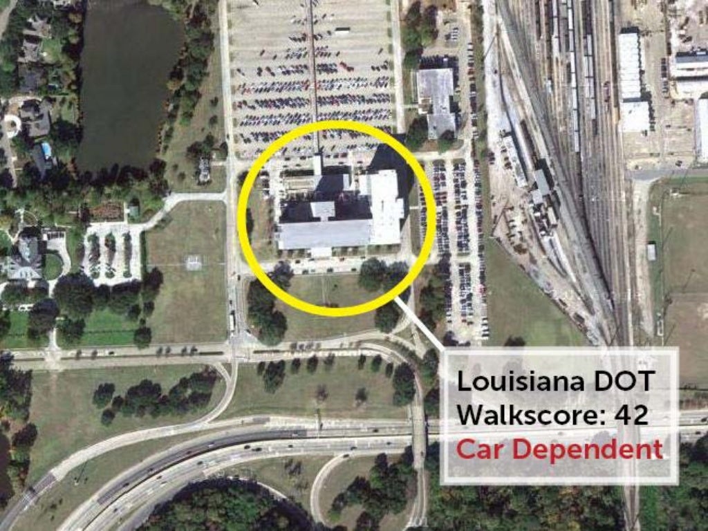
So, lets think about transportation: Who makes the policies and projects which play a huge role in our transportation choices? How does their own world of transportation look?  Well, I would like to think that the folks making decisions are at the pinnacle of knowledge-action on their respective topics.  So, what does it mean that the Louisiana DOT is located so that pedestrian approach is all but futile?

"No walking or biking along interstate", 6th most inaccessible-without-car-DOT in the nation

Monday, April 1, 2013

FTB19: continuing research 4.4.13

Freedom to Build will be meeting Thursday, April 4 at 5pm at the Rosa Keller Library on S Broad St.  You know, the library with a front half thats old n grand, and a back half thats poppin' new and college-architecture-grad-y, with a coffeeshop separating the two.  


New construction (left) houses the library, with added technology focus: more computers and wide selection of DVDs, reflected in that wing's design.  The old building's raising + renovation (right) has space for studying and meeting, open longer hours than the library.  The two are connected by a coffeeshop.  There's a societal metaphor, a sign of the times,  somewhere in there as well.

When a cluster of 5 libraries were planned to be rebuilt, new additions based on public-input meetings included wifi-zones, children's areas, after-hours gathering spaces, and "enterprise space."  I believe that the Green Dot Cafe at Rosa Keller is the only private enterprise that ended up being placed in a library, and I've heard rumors that it isn't open anymore (past 2 times I was there it was closed, no website anymore).  While its ominous to see a glorious public space such as a library have such visible private-capital involvement, the presence of a coffeeshop helped make the library more functional for longer work-sessions, and the various groups meeting in the building seemed to appreciate its existence.  A nice amenity... will a donation-based coffee-maker work as well?   


Is the name of this cafe referencing the "Green Dot Plan" (from Nagin's Bring New Orleans Back Commission) that infuriated so many folks thinking their homes were becoming parks and swampland? from nola.com article

Let's work to finish up our present research, figure out exactly what to do with it, and move to other green-dotted pastures. See you there! Bring pencils/pens and paper, and a computer if you have it... the library closes at 7 and has public computers available until then.